The recent wave of flood in Assam left a trail of devastation affecting a total population of 33, 45,442 people and taking a toll of more than 150 lives. However, unofficial sources claim the death of more than 200 people in the recent deluge. Incessant rains since the first week of July coupled by dam-induced flood claimed 84 lives. The second bout of flood proved a disaster to the state; humans, animals including wildlife being washed away; millions of people displaced; thousands of hectares of standing crops destructed. Embankments were breached in 26 places in 15 districts. The Assam State Disaster Management Authority put the number of flood-hit people taking shelter in 923 relief camps in recent waves of floods at 4,33,918.
Flood ravages National Parks and Sanctuaries
The Kaziranga National Park, a World Heritage Site, the Dibru-Saikhowa National Park, Manas National Park, Nameri National Park, the Pobitora Wildlife Sanctuary and Laokhowa Wildlife Sanctuary were ravaged by the recent waves of flood.
According to the State Forest Department, about 350 animals, including 26 one-horned rhinos, five elephants, a tiger and more than 250 deer perished in the world-famous Kaziranga National Park and Tiger Reserve during the recent waves of flood. However, local NGOs claim more than a thousand animals died in the two waves of floods, especially the second wave that surpassed the record of 1998. The government list has not taken into account lesser wildlife like wild boar, porcupines hog badgers, foxes or even gaurs (Indian bison) and wild buffaloes. More carcasses were found floating once water levels receded while rescued rhino and jumbo orphans were sent to the rehabilitation centre.
With the flood level of the Brahmaputra flowing through the north of the Kaziranga crossed the danger level at Dhansirimukh, 90 per cent of the park got inundated. Most of the existing highlands inside the park were submerged and animals including elephants, buffaloes, rhinos, deer, wild boars were seen crossing the National Highway 37, which cuts through the National Park to take shelter on the Karbi Anglong Hills in the south. In the process, quite a number of wildlife got killed or injured by speeding vehicles on the highway. There are speed limits on but that hardly make a difference to the wildlife waiting late into the night for traffic to thin. Some did not make it. The Assam Government faced severe criticism of the National Green Tribunal (NGT) for death of several animals in road accidents in the Kaziranga National Park (KNP) and was directed to ensure their safety particularly during floods. More than a dozen hog deer were killed in the first week of July in such accidents. Worse, the marooned wildlife taking shelter near human settlements got killed indiscriminately. The guards complained of inadequate frontline staff as well as a minimal number of boats that stalled rescue operations. The Kaziranga National Park, a World Heritage Site and the Dibru-Saikhowa National Park are both ravaged by the recent flood, are biodiversity hotspots in the Eastern Himalayas. KNP hosts two-thirds of the world’s Great One-horned Rhinoceroses. It also boasts the highest density of tigers among protected areas in the world and was declared a Tiger Reserve in 2006. Absence of infrastructure facilities and insufficient manpower brought doom for a sizable wildlife population in Kaziranga and Dibru-Saikhowa. An intense flood like the current one leaves behind a huge wildlife casualty and raises the ever-pertinent question: Why did authorities fail to take any precautionary measure in the flood-prone wildlife zone of Assam?
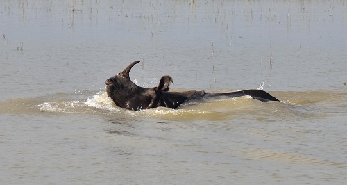
Photo by by Biju Bodo
The second wave of flood devastated the Pobitora Wildlife Sanctuary, known for the highest density of one-horned rhinos in the world. Situated in Mayong Revenue Circle in Morigaon district in central Assam, 14 of the 20 forests camps were totally inundated. The staff was seen struggling with rescue work and keep vigil with shortage of machine boats.
Losses from the other parks and sanctuaries are yet to be ascertained. It is also pertinent to note that there has been fast decline in areas of important wildlife reserves like Kaziranga and Dibru Saikhowa due to heavy erosion.
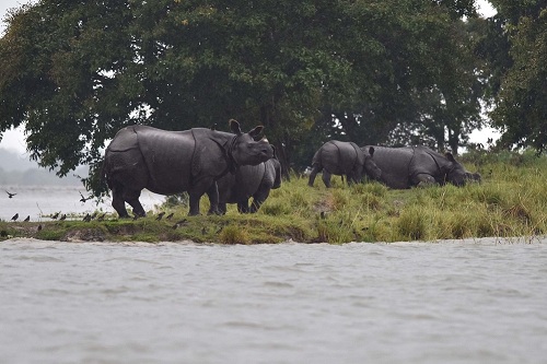
Rhinos taking shelters in highland during flood in Kaziranga. Photo by Biju Boro.
No flood alerts; no preparedness
Every year floods leave the region crippling but with no effective solution or policies, things remain unchanged. There is no regular monitoring of flood situation and no timely warning being issued by states or central agencies about the rainfall and floods.
It is strange that while Northeast is battling floods, there is no timely up date of flood monitoring system under National Disaster Management Authority. The website of the NDMA was updated till June 04, 2017 on July 12, 2017.
Central Water Commission has also failed in issuing timely flood warning in the affected areas. In fact, there was no update for floods in the Ranganadi.
Dam-induced flood wreaked havoc in Lakhimpur-Dhemaji-Majuli
Earlier, flash flood in the Ranganadi wreaked havoc in North Lakhimpur in the early hours of July 10 inundating hundreds of villages in the three districts of Lakhimpur, Dhemaji and Majuli. Surging waters of Ranganadi swept away houses, people and livestock and forced tens of thousands of villagers to flee to safety. The sudden rise of water level in Ranganadi was caused by NEEPCO’s 405-MW Ranganadi Hydro Electric Power Plant at Yazali in Arunachal Pradesh. Water was released from the dam without notice and the administration of the three districts as well as some three lakh people in Lakhimpur district were caught off guard. Flood waters damaged the culvert on National Highway No 15 between Lakhimpur and Dhemaji and washed away a 50-metre stretch of an embankment at Bogalijan in Lakhimpur district, about 5km from North Lakhimpur town. The deluge created by the flash flood surpassed the record of 2008 claiming at least 19 lives.
The State Water Resources Minister recently revealed in a press meet in Guwahati that a state-of-the-art flood-monitoring and flood warning system would be in place soon for effective flood forewarning in the State. Data received for forecasting is important, but there have also been questions on the usage of that data as it is more important to deliver the warning message to prepare the community. The Disaster Management Authority in Assam has failed miserably to make use of shared data and generate an early warning system.
The Ministry of External Affairs’ (MEA) revelation that India did not receive any hydrological data on the Brahmaputra and the Sutlej from China despite having an agreement created ripples. The MEA spokesperson said that there is an existing expert-level mechanism founded in 2006 and two MoUs under which China is expected to share hydrological data on the Brahmaputra and the Sutlej for flood forecast. But no data was shared by China since May. However, he also said, it is premature to link it with the Assam floods. Referring to the MEA statement, Assam Finance Minister Dr Himanta Biswa Sarma during a press conference in Guwahati on August 25 said that even without high magnitude of rainfall in Assam and Arunachal Pradesh, the second wave of flood that started from the first week of August played havoc in Assam. This is intriguing. Even though the MEA feel it is premature to link the non release of hydrological data from China to Assam floods, the core fact remains that China did not share hydrological data and the Assam government is going to pursue that matter with the Central government.
Loss of livelihood
The agriculture sector in the state suffered a huge loss of Rs 193.19 crore. Official sources put 3, 82, 67 hectares of crop area in 31 districts and altogether 5. 04, 370 farm-families been affected. Crop production would fall by 6 lakh metric tone this year. Flood-induced siltation covered some 6,293 hectares of cropland and the damage is maximum in the North Lakhimpur district where 3,565 hectares of agricultural land has been covered by silt rendering it useless, informed State Agriculture Minister, Atul Bora. His department has sought Rs 200 crore from the Centre in view of this large-scale damage. Over seven thousand schools were washed away and 3,423 houses were damaged while 23, 512 houses were partially damaged. The floodwaters also took a heavy toll on livestock. More than 12,000 big and small animals perished in the span of 45 days. The state faced severe infrastructural problems with bridges and some 1,389 roads washed away, creating a huge challenge for the state government.
In Mithaam Chapori, near Numaligarh in Golaghat district, a few families brought down their permanent dwellings to escape the Dhansiri from eating away their belongings and set up make-shift dwellings on the connecting road to the outer world. Aggravating natural disasters like flood and flash flood coupled with changing rainfall patterns play havoc with crop-cycles--force thousands of people to leave their traditional homes from this district each year.
Floods and river-bank erosion pose a grave risk for the entire Brahmaputra valley. Globally, the Brahmaputra river system is perhaps the only one known for its loss of about 100 square kilometres of land every year due to bank erosion.
After the floods the displaced people land in make-shift camps that are always inadequate to cater to the needs of such a large number of flood-affected families and is a telling comment on the disaster preparedness of our national/international policies dealing in disasters.
Challenges for governments
Of late, the northeastern part of the country has experienced the impact of climate change in excessive rainfall, flash floods, abrupt monsoon, longer summers, drought, rising temperatures and increasing pest populations. Subtle changes have already been noted in the monsoon rain patterns. Scientists also warned that rising temperatures will lead to the raising of snowline whereas capacity of natural reservoirs will be reduced that would increase the risk of flash floods during the wet season.Apart from monsoon rains, Assam also is fed by perennial rivers originating from Himalayan ranges in Arunachal. Since the glacial melts coincide with the summer monsoon season, any intensification of the monsoon is likely to contribute to flood disasters downstream.
Further, thoughtless construction of dams on rivers in the name of flood control and the careless operation of dams have converted floods into a disaster. The government has always focused on short term measures like damage assessment and relief and failed to find effective and innovative solutions to tackle the problem. This inability to find a lasting solution has affected the state socially and economically.
The scale of the problem is such that there is no solution at sight. Aging embankments are turning floods a boon of nature into a bane. Over the years only repair works are being carried out due to paucity of funds. This year also repair works were carried out in some embankments including Hatimura that was washed away at Kaliabor wreaking havoc for the entire Nagaon district. In Majuli there were nine incidents of breach of embankment. State Chief Minister Sarbananda Sonowal told a visiting Central team that the state has a proposal to develop embankments as road-cum-embankments stretching to a length of 5,000 km under ‘Prime Minister’s Special Programme for Flood and Erosion Control’. The seven member inter-ministerial Central team which visited the Brahmaputra and the Barak valleys, was witness to the damage and distress and migration of flood-hit people and described the first wave of flood in the state as” profound and large-scale.” Union Minister of State for Home Affairs Kiren Rijiju too, termed the flood fury as “a calamity of severe nature” and apprised the Rajya Sabha on August 10 that the Centre has earmarked Rs 100 crore to find a permanent solution to floods in the northeastern region.
- 11161 reads






Add new comment