

Cloudburst Claim: What Really Caused Upper Assam’s Flood?
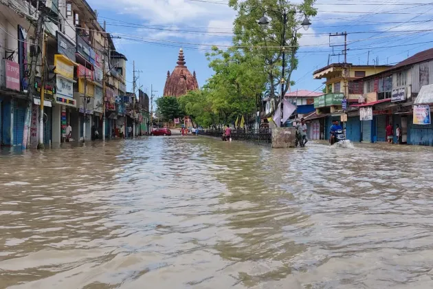

On 19 July, Dr. Bongtao Lunglee called me from Mon district in Nagaland. A landslide had occurred near his home, and he had been observing continuous heavy rainfall across the surrounding hills. He was worried that if the rain continued, the water could move farther downstream and create floods in parts of Nagaland and Assam.
Initially, I did not fully believe him. We often speak casually about rain, landslides and rivers. Such conversations are common during the monsoon. Later, however, I realised that his information should not have been ignored.
Whenever I receive information about such incidents, I normally try to alert people living in vulnerable areas. But that day, another thought came to my mind: Even if I shared the information, who would believe me?
What followed made that conversation impossible to forget.
In Sivasagar, the water did not arrive slowly. It entered settlements with unusual speed and force, leaving families with almost no time to move their belongings or decide where to go.
“Within a few minutes, everything happened. There was no chance to evacuate our belongings,” said Dr Bhaben Mohan, a socially engaged resident of B.T. Road in Sivasagar.
Dr Mohan explained that the lack of flood awareness, preparedness and previous experience made it very difficult for people to take immediate decisions. They did not know how high the water might rise, which place would be safe or how much time they had to leave.
His experience shows how suddenly the disaster unfolded in his locality. The water arrived within minutes. No administrative early warning reached his locality, he said. In his lifetime, he had never seen flooding of comparable intensity there.
This is one named testimony. It does not prove that no warning was issued anywhere in Sivasagar district. But it is enough to ask whether the warning system reached the last person, in the last locality, at a time when protective action was still possible.
The scale of the disaster is equally disturbing. According to the latest Assam State Disaster Management Authority report, as of 23 July 2026, around 3.75 lakh people were affected in Sivasagar, 1.86 lakh in Charaideo and 1.15 lakh in Jorhat. Together, these three districts accounted for approximately 6.76 lakh affected people. These numbers are a rolling administrative snapshot and may change as the assessment improves. But the picture is already clear. Nearly 94 per cent of Assam’s flood-affected population this year has been reported from these three districts. Across 11 districts, the total affected population was recorded at around 7.21 lakh.
For the people of Sivasagar, Charaideo and Jorhat, this appears to be the worst disaster situation since 1950.
The disaster is taking place on the south bank of the Brahmaputra in Upper Assam. It is not in the Barak Valley districts, which are often referred to as “Southern Assam”. The main impact belt runs through Sivasagar, Charaideo and Jorhat, including Nazira, Amguri, Simaluguri, Demow, Sonari, Teok and the adjoining tea-growing and farming areas.
These places were once considered among the safer areas of the Ahom kingdom. But floods and related calamities are not completely new to this landscape. During the reign of Gadadhar Singha, a major flood was recorded in 1691. During the Moamoria conflict, another severe flood was recorded in 1793 in the Tungkhungia Buranji. The earthquake-related disasters of 1897 and 1950 also affected these districts.
If we look at the region through a disaster lens covering the last 500 years, we can see that major natural calamities have returned at significant intervals. Earlier, such a disaster interval appeared to be around 100 years. That interval now seems to be shortening to between 50 and 75 years.
Whether we call it a natural cycle or a changing pattern, the question remains the same: Are we prepared enough to face such potential calamities? Or have we been made to forget the past, when that past should have been used to design our preparedness?
On the other way, when we discuss floods in Assam, we cannot ignore what is happening in the surrounding hills. For the present flood, the Naga Hills are a significant location to understand.
The Dikhow River originates in Zunheboto district of Nagaland. It enters the Assam plains through Naginimora, crosses Sivasagar and finally meets the Brahmaputra. Its basin covers around 4,372 square kilometres.
The Disang basin also includes a large hill catchment in Mon district and adjoining parts of Arunachal Pradesh. The Jhanji and Bhogdoi river systems similarly include catchment areas inside Nagaland.
This creates a real hills-to-plains flood relationship. Intense rainfall over Mon, Longleng, Mokokchung or Zunheboto can quickly turn into runoff. The water then travels through steep tributaries towards Sivasagar, Charaideo and Jorhat. When it reaches the flatter Assam floodplain, its movement slows and drainage becomes more difficult.
But this time, something unusual happened. The water came down furiously, carrying heavy loads of debris and greater energy. Why this happen? The condition of the hills also needs serious attention.
Fewer stones now remain in the foothill sections of many of these rivers to help reduce the force of the water. Legal and illegal mining has removed a large quantity of stable riverbed material. In many places, mining has cut into the body of the river itself.
Above it, if one travels from Naginimora towards Mon or Tuensang, it is possible to see how slopes across fragile hill areas are being cut for roads and other infrastructure. Excavated soil, rocks and construction debris are often pushed towards streams and riverbeds. Roads are unquestionably necessary for hill communities. The issue is not whether roads should be built. The real issue is how they are being designed and constructed. Are the alignments suitable for such fragile slopes? Is proper slope stabilisation being done? Are enough cross-drainage structures being provided? Is erosion being controlled? Is excavated material being safely disposed of?
When these safeguards are missing, a road does not remain only a road. It can change the direction of water, block a natural stream, increase erosion and send soil and debris into the river system. This is why Assam and Nagaland cannot manage these rivers as separate administrative problems. A river does not stop at the state boundary. Water falling in the hills of Nagaland can become a flood in the plains of Assam within a very short period. The upstream rain gauges, weather radar observations, river gauges and landslide information from Nagaland must therefore become part of Assam’s downstream early-warning system. In the same way, flood impacts in Assam should be treated as evidence of changes taking place across the wider shared catchment.
My visits to these upstream and downstream areas during the last two years have taught me that riverbed levels are increasing while the water-carrying capacity of the rivers is decreasing.
The quantity of water that these rivers may have carried through their channels 400 years ago may no longer be carried through their present channels. Sediment, debris, construction waste and changes in riverbeds have reduced the space available for water. Cut-and-dump construction practices in the upstream areas are also clogging natural drainage. The Namdang River itself is an example of how we have gradually turned a river into a nallah.
The problem does not end there. Railway lines, highways and other east-west road networks have been constructed across this landscape. In many places, they do not provide adequate passages for water to flow naturally. These structures have made the landscape more complex and intensified the present situation. Many wetlands and large pukhuris that once stored excess water are no longer there. Settlements have also become increasingly visible very close to rivers and natural drainage channels.
When the river’s carrying capacity decreases, wetlands disappear, drainage routes are blocked and settlements expand towards the water, heavy rainfall can quickly turn into a human disaster.
Then again it brings us back to discuss about the early warning.
An early-warning system cannot be judged only by the time at which a bulletin leaves an office. It must be judged by whether the message reaches a family, whether the family understands the threat and whether the message arrives early enough for them to take protective action. A proper review of this flood should compare upstream rainfall and river-gauge timings with control-room records, bulk mobile messages, sirens, local volunteer networks, tea-estate communication systems, evacuation orders and interviews with affected and neighbouring households.
Perhaps the Charaideo and Sivasagar administrations were not adequately prepared for an event of this scale. It is possible that they did not anticipate that the water would arrive with such speed and force. They may also have had limited experience in managing a flood of this nature. These possibilities must be investigated, not to blame individuals, but to ensure that the same failure is not repeated.
Meanwhile, a new explanation for the disaster has emerged—the claim that it was caused by a “cloudburst”. Even the Chief Minister of Assam, through social media, attributed the disaster to a cloudburst.
But where is the evidence?
The India Meteorological Department defines a cloudburst as extremely intense rainfall—around 100 millimetres or more within one hour over a small geographical area. A daily rainfall total of 137 millimetres alone cannot confirm that a cloudburst occurred. Location-specific and hour-by-hour rainfall data are required before such a claim can be established. The issue is not that a cloudburst was impossible. The issue is that a meteorological term should not be used as the final explanation without proper evidence.
More importantly, even if a cloudburst is scientifically confirmed, it would describe only the rainfall event. It would not explain the complete disaster. A cloudburst cannot by itself explain why water entered particular settlements within minutes. It cannot explain why an embankment failed or was overtopped. It cannot tell us whether drains and culverts carried their designed flow, why natural drainage routes were blocked, why wetlands disappeared or why houses and critical services were located in the deepest paths of inundation. It also cannot explain why some families received very little time to evacuate or why warnings did not reach every vulnerable locality in a usable form.
Therefore, we should not blame a cloudburst for every flood. An unverified cloudburst claim can divert public attention from the full chain of risk: the condition of rivers and channels, sediment and debris, embankment maintenance, drainage bottlenecks, riverbed mining, the loss of wetlands and floodplain storage, land-use change, settlement exposure, interstate data sharing, early-warning performance and emergency preparedness.
The flood may have come from the hills, but the explanation cannot stop there.
Looking to the present situation in these three districts the intensity of the flooding, the number of affected people, the scale of the losses and the casualties show that recovery will not be easy. Many families have lost food sources, household materials, livestock, crops and their immediate sources of income.
A comprehensive post-flood management and recovery plan must now be put in place by the government. It may not be possible for the administration alone to reach every affected person. Local communities, civil-society organisations, health workers, volunteers and tea-estate networks must also be involved.
Access routes and local supply chains have also been disrupted. The immediate responsibility is to ensure that relief reaches every affected family. Many families will face shortages of food and safe drinking water. Medicines will be especially important for elderly people and those who depend on regular medication.
The larger responsibility is to learn from this disaster. The question is not only whether a cloudburst happened. The real question is why heavy rain became such a sudden and destructive disaster—and whether we are prepared to prevent the same thing from happening again.
Comments (0)
No comments yet. Be the first to share your thoughts.
Leave a Comment