

Assam battles multiple flood fronts as flash floods, overflowing rivers and disrupted transport compound monsoon crisis
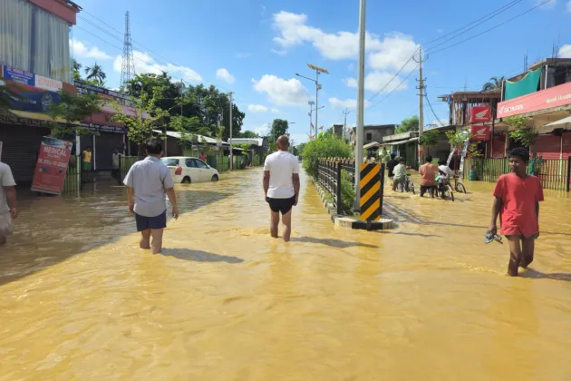

GUWAHATI, July 21, 2026 — Assam is battling one of the most complex flood situations of the current monsoon season, with different parts of the state simultaneously facing flash floods, overflowing hill rivers, swollen tributaries and urban inundation, exposing the vulnerability of the state's diverse river systems to increasingly intense rainfall events.
While annual flooding associated with the Brahmaputra remains a recurring feature of the monsoon, the latest crisis has unfolded through multiple hydrological systems. The worst-hit districts in Upper Assam—Sivasagar, Charaideo and Jorhat—have been devastated by flash floods triggered by torrential rainfall in neighbouring Nagaland, while districts along the north bank continue to face rising waters from rivers descending from Arunachal Pradesh. Elsewhere, heavy local rainfall and overflowing tributaries have aggravated flooding across central and lower Assam.
The latest official estimates indicate that more than 3.6 lakh people have been affected across 15 districts, with hundreds of villages inundated and extensive damage reported to houses, roads, agricultural land and tea estates. At least five flood-related deaths were reported on Monday, taking the monsoon toll higher as rescue teams continued operations across the state.
The most dramatic situation has emerged in Upper Assam, where heavy rainfall over the Nagaland hills sent huge volumes of water rushing through rivers and streams such as the Dikhow and other hill-fed channels into the plains. Unlike the gradual rise associated with the Brahmaputra, residents reported that floodwaters entered villages within hours, inundating homes, markets, roads and tea gardens in Nazira, Amguri, Sonari, Mariani and surrounding areas.
Nazira subdivision in Sivasagar district has emerged among the worst affected, with more than 57,000 people impacted and several tea estates remaining under water. The inundation has disrupted estate operations and raised concerns over crop losses during a crucial phase of the tea season.
The floodwaters have also severely affected transportation. Railway operations between Dimapur and Dibrugarh were disrupted after floodwaters submerged the railway station yard and tracks at Simaluguri. Northeast Frontier Railway suspended train movement on the affected section, forcing the cancellation, diversion or short-termination of more than 30 passenger and express trains. Thousands of passengers were stranded before railway authorities arranged road transport and alternative rail services.
Road connectivity has also been disrupted in several flood-hit districts, with highways, district roads and village roads remaining under water. Several low-lying villages continue to remain cut off, making relief operations difficult.
In response to the worsening situation, the Assam government has intensified rescue and relief efforts by deploying the State Disaster Response Force (SDRF), National Disaster Response Force (NDRF), district administration personnel and local volunteers. The Indian Army has also joined rescue operations, while the Indian Air Force has been kept on standby for emergency deployment if required. Chief Minister Himanta Biswa Sarma has assigned four cabinet ministers to supervise rescue, relief and rehabilitation work in the worst-affected districts.
Beyond Upper Assam, flood conditions continue in parts of Lakhimpur, Dhemaji, Sonitpur and Biswanath, where rivers originating in Arunachal Pradesh have swollen following heavy rainfall in the eastern Himalayan catchments. Central Assam districts, including Nagaon and Morigaon, are witnessing flooding caused by local rainfall and rising tributaries, while parts of lower Assam continue to face waterlogging as the Brahmaputra and its tributaries gain volume.
The present flood emergency illustrates the growing complexity of flood management in Assam. Instead of a single river-driven disaster, the state is now confronting overlapping flood systems generated by heavy rainfall across neighbouring hill states including Nagaland, Arunachal Pradesh, Meghalaya and Bhutan. The situation has highlighted the need for integrated basin-wide flood forecasting, improved inter-state coordination on upstream rainfall monitoring and stronger early-warning systems for vulnerable foothill districts.
Relief camps have been opened across affected districts, and food, drinking water and medical assistance are being provided to displaced families. However, residents in several remote villages and public representatives have alleged delays in the delivery of relief materials, particularly in areas where road communication has been completely severed.
The India Meteorological Department has warned of continued heavy rainfall over parts of Northeast India, raising concerns that additional precipitation over upstream catchments could trigger fresh surges in the hill rivers flowing into Assam. Authorities have advised people living in vulnerable low-lying areas to remain alert and cooperate with evacuation and rescue teams as the situation continues to evolve.
Comments (0)
No comments yet. Be the first to share your thoughts.
Leave a Comment