

The basic approach is to convert Bhramaputra itself into a series of reservoirs. In General the width of Bhramaputra varies between 12 Km to 20 Kms and bed slope is very less, therefore it is possible to convert different reaches of Bhramaputra into big reservoirs by constructing rock filled earthen embankment dams of about 20 m height. We find that five reservoirs can be constructed from Jonai to Goalpara. Flood discharge of Bhramaputra, which is about 100,000 cubic mtrs/s near Bangladesh border can be brought down to normal average i.e. 19300 cubic meters/Sec and excess flood water gets stored in "Asom Sagar" and North Lake and South Lake which are lakes running north and south sides of Assam and are joined with "Asom Sagor I" in upper reach.
Lake as proposed in BARAK River Valley will stop floods in BARAK valley. We have named it as Silchar Lake.
"ASOM SAGOR" – benefits:
- SELF SUSTAINABLE FINANCIALLY LUCRATIVE SOLUTION for stopping flood and drought, power generation, employment and revenue generation Assam.
2.STOPPING FLOOD – Asom Sagor completely stops floods in Asom and along with it the massive destruction caused by it in terms of property and lives every year will also stop. There will be no damage to existing infrastructure system like roads, railway line, power distribution etc. which in turn will be great saving. The huge amount spent on flood management schemes and rehabilitation of the people will also be saved.
3.ELIMINATING DROUGHT -Water from North Lake and South Lake will irrigate drought prone areas and will eliminate drought condition in entire Asom thus increasing agriculture production and economic condition of people of Asom.
4.EMPLOYMENT GENERATION: The project will create huge employment opportunity, about 150 lakhs people are going to get direct or indirect employment for all the time during the completion of the project and after completion.
5.POWER GENERATION: Northern and Southern Asom lakes has got vast potential of power generation by utilizing the flood water. Micro Hydel Projects can be set up on North side and South side of Bhramaputra. Future needs of power of Asom can also be met by Asom lakes.
6.AGRICULTURE: Lakhs of acres of additional areas will get irrigation. A planned crop pattern will result in increased yield and efficient water management.
7.DRINKING WATER: Entire Asom villages will be able to get drinking water. Availability of power will make it possible for remote areas also. Most of the places it will be possible to provide drinking water through gravity flow.
8.INDUSTRIAL GROWTH: Availability of power will give boost to small and medium scale industries and agriculture based industries.
9.EXPRESSWAY: Expressway will be constructed on the banks of North lake and South lake. This expressway will connect East-West through the Chicken neck. High speed two lane on each embankment. Expressways cut down the time of travel drastically and expected to collect huge amount of revenue through Toll.
- FISHERIES: Fresh Water fishes will be produced. It will give boost to the fisheries because Asom Sagor is a big reservoir.
- TOURISM: It will give boost to the tourism in state. It is expected that international tourism will increase and lot of foreign exchange will come to the state. Attractive tourist spots will be developed along the Asom Sagor. Water sports like water skiing, swimming, SCUBA Diving can be provided in the Sagor.
- NO INVOLVEMENT OF any other state.
- INLAND WATER NAVIGATION: Asom Sagor and North & South Lakes will be used for in land water navigation. High speed motor boats can be run in Sagor from East to West and North to South.
- TEA PRODUCTION: More tea garden’s in Barak Valley can start production once the flood is controlled by constructing Silchar Lake.
PERMANENT SOLUTION FOR FLOODS AND DROUGHT, POWER GENDERATION, INLAND WATER WAYS, IRRIGATION
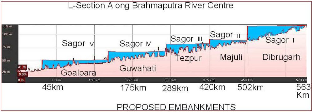
- BHRAMAPUTRA RIVER VALLEY The present scheme has been created to cater for heavy floods of Bhramaputra river which is about 100,000 cubic metre/s near Bangla Border. Basic concept of the scheme is to convert Bhramaputra river itself in to big reservoirs by constructing rock filled earthen Embankment Dams across the river. We propose creating 5 reservoirs in the Bhramaputra between Jonai and Gopalpara. First Earthen embankment dam proposed to be constructed is down stream of Dibrugarh. Approximate location of Earthen embankment dams and reservoirs is marked on satellite imagery.
The average discharge of Bhramaputra river is about 19,300 cubic meters/ sec and floods can reach over 100,000 cubic metres per second.
- Depths and Water levels of Bhramaputra.
Under ordinary flow conditions maximum depths of main channel with respect to adjacent islands or flood plains areas are typically in the range of 10 to 20 meters, tending to increase in down stream direction. Rise in water level from low water to high flood stages are around 8 metres.
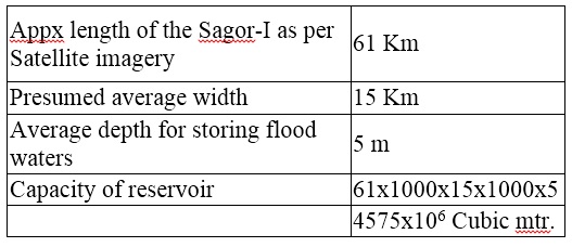
- Suitable sites for Embankment Dams The proposed embankment dams are to be constructed where depth is minimum and width is maximum so that we get maximum storage area and minimum embankment dam height. The height of embankment dams proposed by us is about 20 meters. Taking average width of Bhramaputra about 15 Kms, the capacity of SAGOR-I to store water, presuming an average depth of water available for storing flood waters as 5 meters, and length which is about 61 km is upto 4575 x 106 cubic meter.
There are 28 major tributaries on north right bank and 16 on South or Left Bank of Bhramaputra river.
The maximum discharge of the river at Pandu (in Guwahati) on 23.08.62 was 72,794 m3/S and the mean annual flood discharge and dry season discharge of the river at Pandu is 51156 m3/S.
- SILT SOLUTION
Spillway dams will be constructed across all the tributaries and Bhramaputra to work as “SILT TRAP” with a aim to stop silt from reaching reservoirs. Dredging of silt will be required to be done from silt traps or suitable silt excluders are to be provided to remove silt from silt traps.
- MAJULI ISLAND
MAJULI ISLAND, which is Asom’s cultural capital and one of the largest river island in the world will be protected from flood water of Bhramaputra and also from any kind of flood water of lower Subhansari river.
- KAZI RANGA
Kazi Ranga National Park will be saved from the flood waters of Bhramaputra River and the animals of the park will be protected.
- RESERVOIRS, NORTH & SOUTH LAKES
The North Lake and South Lake are all along north and south of Asom in which all the tributaries will fall. North and South lake form part of First Reservoir above Dibrugarh and their bed level is about 105 m. We have named the reservoirs on Bhramaputra as Sagor. First Reservoir is named as SAGOR-I. In first phase SAGOR-I, the upper most reservoir should be constructed and simultaneously north lake and south lake construction should be done. The project is to be completed in phases.

- STORAGE CAPACITY OF SAGOR (RESERVOIRS) Taking average width as 15 Km and average available depth as 5 meters for storing excess flood water as a sample for estimation we take Sagor-I:
- Taking Bhramaputra’s flood discharge upstream of Dibrugarh as 80,000 cum/s and allowing 30,000 cumec/s through spillways in regular channel.
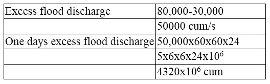
Thus one days excess flood discharge can be accommodated in storage reservoir-I i.e. SAGOR-I. Similarly calculations can be done for all reservoirs and lakes.
Taking width of North Lake and South Lake, as 500m and the height of embankment dams as 15m, we calculate the storage capacity of lakes.
Keeping 4m as dead storage level, 9m as live storage and 2m free board and the length of North Lake = Appx. 525 Kms.
Width at dead level = 500 + 24 = 524m
Width at highest level = 500 + 78 = 578m
Average width = (524 + 578)/2 = 1102/2= 551m
Flood water storing capacity of the lake = 525 x 1000 x 551 x 9 m3 = 2603.5 x 106 m3
Similarly we can calculate for south lake and Silchar lake.

PROPOSED X-SECTION OF NORTH LAKE, SOUTH LAKE AND SILCHAR LAKE WITH EMBANKMENT. Asom north lake and Asom South lake also form part of SAGOR-I
Following general precautions will need to be taken during construction.
- All the lakes will be constructed in sections of appx. 50Kms in length each, such that every section can be isolated in case of emergency and for maintenance.
- We will have sufficient number of sluice gates to control water level in each section. In case of emergency and during floods, water level can be brought down by opening these gates.
- Cross drainage will be provided by making culverts and aqueducts.
- BARAK RIVER VALLEY

Silchar and surrounding areas fall under Barak river valley. The quoted maximum discharge of approximately 6,700 m3/s near the east end of the plains and 7800 cubic meters per second near the west end.
We propose constructing a lake all around periphery of the valley keeping bed level at about 30 M above MSL and by using embankment dam of about 15m high. An expressway/ Highway to be constructed for communication on top of embankment. Lake will be used for inland water communication also. Excess flood waters of Barak river and flood waters from Meghalaya rivers and Tripura rivers will be stored in this lake and subsequently used for hydropower generation.
The capacity of the lake will be sufficient to cater for all excess flood waters and will thus stop flooding of the area.
© by Author. The author can be reached at: navinchandra09@gmail.com.
- Add new comment
- 18557 reads


Comments
There should be a
Add new comment