

Many hands, no single grip: the coordination paradox of flood relief in Sivasagar
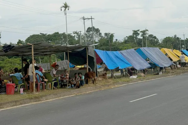

When the Dikhow and Dorika rivers breached extreme flood levels following heavy rainfall upstream in Nagaland, the surrounding districts went underwater within hours. What followed was, on the surface, an impressive mobilisation. The Deputy Commissioner's office, the municipality, the National Disaster Response Force (NDRF), Civil Defence units and Village Defence Parties were all visibly at work.
Yet, for anyone watching the relief effort unfold over the following days—an MLA wading through a flooded street, another personally hauling a rescue raft with security personnel and a camera crew in tow, and the Chief Minister visiting one or two relief camps—the impression was not of a well-oiled machine. The energy and intent were unmistakable; coordination, however, was far less evident.
The paradox is worth examining. How can a disaster response involve so many agencies and still appear uncoordinated? More importantly, did a real operational blueprint exist, or did each institution end up improvising its own response?
An architecture does exist. It would be wrong to say Assam has no disaster management plan. In fact, Assam has one of the more elaborate disaster management frameworks in the country. The Disaster Management Act, 2005, created a cascading structure: the National Disaster Management Authority at the top, the Assam State Disaster Management Authority (ASDMA), chaired by the Chief Minister, and District Disaster Management Authorities (DDMAs) in every district under the Deputy Commissioner.
Sivasagar's District Disaster Management Plan is revised annually. On paper, roles are clearly defined. The Deputy Commissioner functions as the Incident Commander. The NDRF and SDRF undertake specialised rescue operations. Municipal bodies oversee civic infrastructure and sanitation. Civil Defence and Village Defence Parties form the first line of community response. The Incident Response System is intended to ensure a unified command structure linked to the State Emergency Operations Centre in Guwahati, where district-level information is meant to converge in real time.
The blueprint for centralised control therefore exists. What appears to have broken down was not the design of the system but its execution under stress.
Several structural constraints undermine even well-designed disaster response systems, and none of them is unique to Assam.
The first is speed. Flash floods triggered by intense rainfall leave little time for graduated warnings. Whether forecasting could have been improved or communication made more effective will remain a matter for review. Equally significant was the rapid spread of unverified reports, including rumours of cloudbursts, exposing weaknesses in official information dissemination. In a region that is seismically active, riverine and increasingly influenced by upstream hydrological interventions, rapid-onset flooding cannot be treated as an out-of-syllabus event. It must be central to preparedness planning.
The second constraint is infrastructure. The very disaster the system is meant to manage often disables the tools on which it depends. Floods knock out mobile towers, disrupt electricity and isolate roads. Once communication fails, local officials are forced into ad hoc decision-making—not because they are ignoring the chain of command, but because the chain of command has literally gone dark. Even so, this is a weakness that preparedness must anticipate rather than accept as an excuse.
The third, and perhaps least discussed, is the asymmetry of visibility. A Deputy Commissioner working inside a control room—allocating resources, matching supplies with demand and monitoring rescue operations—is performing exactly the role envisaged under the disaster management framework. That work is indispensable, but largely invisible.
By contrast, elected representatives wading through floodwaters or visiting relief camps generate powerful images of leadership and empathy. Camps featured on official itineraries may receive disproportionate attention, while equally affected but less visible areas risk delayed assistance. It highlights a structural tension: symbolic presence and operational efficiency can sometimes compete for the same limited administrative capacity.
Public perceptions of poor coordination may therefore partly reflect a visibility bias. An outside observer cannot always distinguish effective command from ineffective command based solely on photographs or television footage.
Still, it would be too generous to dismiss the criticism as merely a problem of optics. A recurring concern after almost every major flood in Assam is that political leaders conducting highly visible rescue activities may unintentionally undermine coordination rather than strengthen it. If a Chief Minister's visit requires a relief camp to be "presentable", resources may be quietly redirected to satisfy protocol instead of addressing the most urgent needs elsewhere.
This is not to suggest that visits by elected representatives lack value. They can reassure affected communities and accelerate administrative responsiveness. However, visibility and coordination do not always move together.
The ambition should be genuine centralised monitoring from which the entire relief operation can be supervised in real time. Achieving this requires far more than drafting a disaster management plan. It demands a culture in which the Deputy Commissioner's authority as Incident Commander is respected in practice by every agency involved. It also requires political leadership willing to channel its own public engagement through the control room's information rather than making field-level decisions that the control room must subsequently accommodate. Above all, disaster plans must be rehearsed in years without floods with the same seriousness with which they are implemented during flood years, especially when districts such as Sivasagar, Jorhat and Golaghat experience flooding almost every monsoon.
There is another dimension that deserves closer scrutiny: who is actually best equipped to move through flooded terrain?
Rescue and relief distribution are not generic skills. Knowing which roads remain passable, which embankments have weakened, where currents are strongest and which households are truly cut off is knowledge possessed by local communities far more than by well-intentioned teams arriving from Guwahati or Dibrugarh.
This became particularly relevant during the recent floods, which witnessed an impressive mobilisation of civil society. Volunteers, NGOs, community organisations, medical teams and private citizens arrived from neighbouring districts carrying food, medicines and other essential supplies. Reports and social media posts showed long lines of private vehicles and relief teams converging on the same easily accessible camps.
It is also fair to ask whether the concentration of volunteers and relief teams at the most visible locations reflected the absence of central coordination rather than deliberate planning. Without a common coordination mechanism, well-intentioned efforts can unintentionally converge on the same places, leading to duplication of resources while more remote villages remain underserved.
The result is predictable: when multiple independent groups converge on the same relief camps, duplication becomes almost inevitable, while remote villages remain underserved. Public compassion becomes significantly more effective when properly coordinated.
Existing disaster management frameworks explicitly recognise this. Donations, volunteers and civil society initiatives are most effective when channelled through the District Disaster Management Authority or designated partner organisations operating under official supervision. These agencies maintain real-time situational awareness, enabling them to prioritise needs, allocate resources efficiently and minimise duplication.
The presence of multiple agencies in Sivasagar's flood response is not, in itself, the problem. It reflects the division of responsibilities established under law nearly two decades ago. The real question is whether the gap between planning and execution can be closed. A blueprint exists. Whether Assam's institutions can make that blueprint visible on the ground—and ensure that every official and voluntary relief effort is channelled through it—remains an open question.
It is a question that resurfaces, almost unchanged, after every major disaster in the region.One can only hope that this time the lessons are learned.
Comments (1)
Well said.. Dot on!
Leave a Comment